By Kandice Watson (Wolf Clan), Documentarian
The French and Indian War and The Revolutionary War were very difficult times for the Oneida Indian Nation. The Mohawk Nation suffered greatly as well, having been the first Haudenosaunee Nation to make contact with non-Indians. The Haudenosaunee Nations were not sure which side to align themselves with during these wars, and the Oneidas found it especially difficult. During the French and Indian War, most sided with the British, only because they had already established a relationship with Sir William Johnson. However, during the Revolutionary War, Oneidas had changed their view and sided with the American colonists over the British.
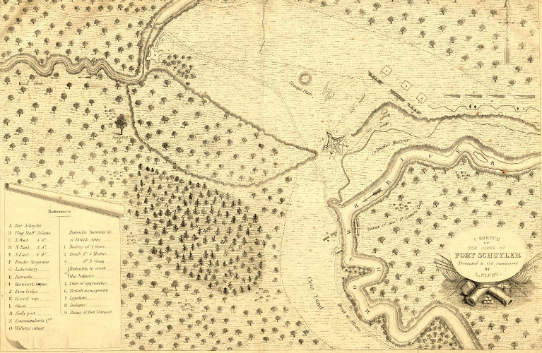
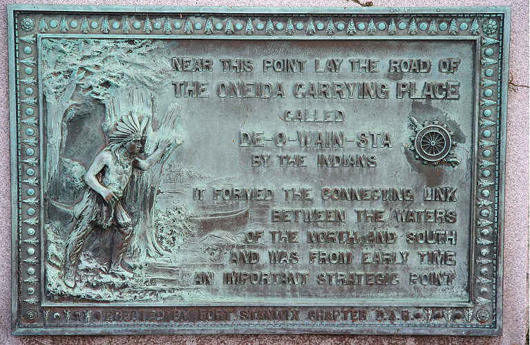
During the 1750’s, the Oneidas occupied and had jurisdiction over a very large swath of land located in what is now known as Central New York. Inside this swath of land was a 2-3 mile stretch (depending on the season) known as the Oneida Carrying Place (aka Oneida Carry). It was called Deo-wain-sta (Tiowestah) by the Oneidas at the time.* This stretch of land was important because this is where the people would land their canoes from the Mohawk River, carry them across the land and then put them into Wood Creek about 2 miles further west. This creek eventually emptied into Oneida Lake, and then travelers could go further on to the Seneca River, up through the Oswego River and then into Lake Ontario. This small section of land became very important during both wars, as it was the main supply route to Oswego and other points north. Carrying supplies up the Hudson to the St. Lawrence was definitely an option, but by taking things directly across the state, they saved time and resources.
The Oneidas had been protecting this valuable stretch of land for many years and were eventually approached for permission to allow a fort to be built near the Carry for protection from the French. The Oneidas agreed on the stipulation that it be torn down after the war. Altogether, seven forts were constructed near the Carry by the British to prevent the French from occupying the area.
According to the National Park Service, Fort Williams (1755) was built on the Mohawk River side of the Carry and Fort Bull (1755) on the west side, near Wood Creek. A third fort, Fort Newport, was constructed in 1756 on the upper landing of Wood Creek to protect the Carry. A dam was built there to increase the flow of water into the creek and shortened the time it took to traverse the Carry. In 1756, on the Mohawk River side, a five-cornered fort was built to replace Fort Williams after it was destroyed by the French. This fort was sometimes referred to as Fort Pentagon, but was officially named Fort Craven. In 1756, Fort Wood Creek (aka Fort Eagle) was built near Fort Bull, though some say directly over it, after it was destroyed by fire.
In September 1756, British General Webb heard intelligence that the French were going to attack the forts surrounding the Carry, so he had them all destroyed and the British took refuge at German Flatts. They began to reoccupy the Carry by the summer of 1758, and in August, construction began on Fort Stanwix. A smaller fort, Fort Rickey, was built in 1759 west of Wood Creek.
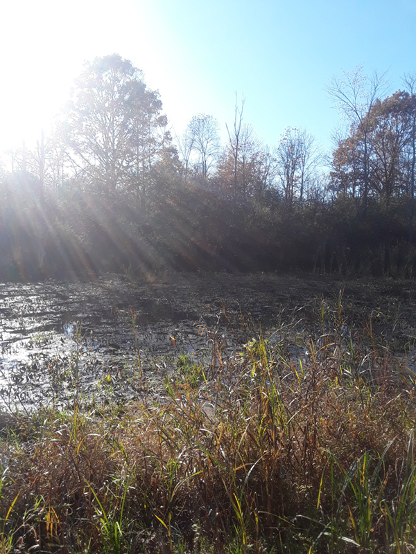
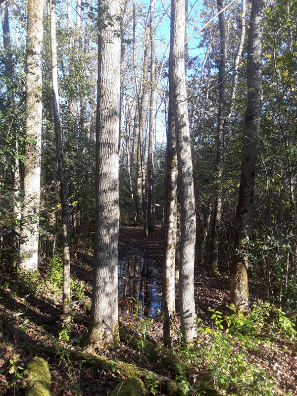
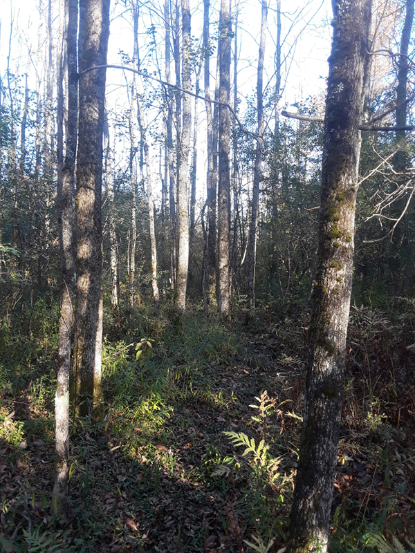
A recent visit to the area where Fort Bull was located on Wood Creek brought this important Oneida history into focus for me. A segment of the Carry still seems to exist near Fort Bull and remnants of the damned-up pond are still visible as well. The footprint of Fort Bull (or Fort Wood Creek) is clearly visible to the naked eye, and the area has one giant oak tree, believed to have been standing when the fort was constructed.
The time period between the French and Indian War and the Revolutionary War was a time of peace for the Carry. The British eventually abandoned Fort Stanwix, which was later used in the Revolutionary War and renamed Fort Schuyler. Many important treaties were negotiated at Fort Schuyler between the American colonists and the Haudenosaunee, although many were not legal.
The fort was occupied by Americans during the Revolutionary War, butin August 1777, it was attacked by the British during a three-day siege. The Americans were able to hold off the British, but the fort was severely damaged. It burned to the ground in May, 1781.
In 1792, the Western Inland Lock Navigation Company constructed a canal between the Mohawk River and Wood Creek, eliminating the need for the Carry. This canal remained in use until 1817.
In 1960, discussions began in the City of Rome regarding reconstruction of Fort Stanwix. It took many years of debate and compromise, but reconstruction of the fort began in 1974, and was completed in 1978. Today, visitors to the fort have a very good understanding of the living conditions and daily life of the soldiers encamped there during the wars. However, I am not sure all visitors are aware of the Fort’s strategic location to the Carry and may instead wonder why it was built in what seems like the middle of the frontier wilderness.
Today, the City of Rome sits atop the Carry, but some signage in the form of historical markers indicate certain spots where the Carry was known to have passed through. A marker on West Dominick Street erected by the Daughters of the American Revolution was placed to signify that the Carry passed through that area. By looking at a current map of the city today, the Carry Road seems to follow Route 46 (Rome New London Road) through to the west side of the city, around today’s Fort Rickey Game Reserve.
* An inquiry to the language department did not yield a meaning for this word. “They carry their canoes” would have been latihuwaha:wí.


